
User:Ty's Commons
Ty's Commons is dedicated to making available new and revised images in support of Wikimedia Commons users worldwide.
Local Scenes
[edit]-
 Langlade, Gard (view from the Cavalier Windmill)
 -
.jpg/330px-Aix-en-Provence_-_Tour_de_l%27horloge_(1510).jpg) Aix-en-Provence - Tour de l'horloge (1510)
Aix-en-Provence - Tour de l'horloge (1510)

.jpg)
Maps of Europe
[edit]In support of fellow researchers, historians and others interested in Europe and the evolution of its countries over time, I've selected and digitally enhanced hundreds of detailed maps - covering most of Europe from the time of the Roman Empire to the 20th century.
While simple png and svg maps are fine for making basic points - such as a migration route or a border change - they typically lack detail. They sometimes also raise questions regarding accuracy because they've often been drawn by an unknown artist based on sources that may or not be clear.
Professional historians and cartographers (including some scholars who were both) have produced highly detailed maps that were also subject to review by their peers and others. Several of these are noted below:
| Gustav Droysen (1838–1908) |
|||
|---|---|---|---|
 |
|||
| Alternative names |
Johann Gustav Ferdinand Droysen | ||
| Description | German historian of Modern Age and university teacher | ||
| Date of birth/death |
10 April 1838 |
10 November 1908 | |
| Location of birth/death |
Berlin |
Halle (Saale) | |
| Work location | |||
| Authority file | |||
| Paul Vidal de La Blache (1845–1918) |
|||
|---|---|---|---|
 |
|||
| Alternative names |
Paul Vidal de la Blanche | ||
| Description | French geographer and cartographer | ||
| Date of birth/death |
22 January 1845 |
5 April 1918 | |
| Location of birth/death |
Pézenas |
La Seyne-sur-Mer | |
| Authority file |
| ||
| William Robert Shepherd (1871–1934) |
|||
|---|---|---|---|
.png) |
|||
| Alternative names |
William R. Shepherd; William Shepherd | ||
| Description | American cartographer and historian | ||
| Date of birth/death |
12 June 1871 |
7 June 1934 | |
| Location of birth/death |
Charleston |
Berlin | |
| Work location | |||
| Authority file | |||
Maps from these and other cartographers have been selected to provide detailed information about the territories of Europe as they have evolved over its complex history.
The maps have been digitally enhanced to improve their readability, organised by region and country, and then arranged chronologically to facilitate finding a map for whatever particular area and time is of interest. Some compression has been applied to reduce file sizes (and smaller versions are available on each page) - but the goal has been to maintain sufficient detail that individual areas and locations can still be seen. If png and svg maps are like a book cover or advert, these are intended to be as close to the original books as possible.
The overall collection for Europe is regularly updated at the following Wikimedia Commons page:
The following sections provide detailed maps showing the regions and individual countries of Europe as they evolved:
- 🇦🇹 Austria
- The Balkans / Southeastern Europe to the Levant
- The Baltics (🇪🇪 Estonia, 🇱🇻 Latvia and 🇱🇹 Lithuania)
- Benelux countries (🇧🇪 Belgium, 🇳🇱 the Netherlands and 🇱🇺 Luxembourg)
- 🇨🇿 Czechia
- 🇫🇷 France
- 🇩🇪 Germany
- 🇭🇺 Hungary
- Iberian Peninsula (🇪🇸 Spain and 🇵🇹 Portugal)
- 🇮🇪 Ireland
- 🇮🇹 Italian Peninsula
- 🇵🇱 Poland
- 🇷🇴 Romania and 🇲🇩 Moldova
- Scandinavia (🇩🇰 Denmark, 🇫🇮 Finland, 🇳🇴 Norway and 🇸🇪 Sweden)
- 🇸🇰 Slovakia
- 🇨🇭 Switzerland
- 🇬🇧 United Kingdom (🏴 England, 🏴 Scotland and 🏴 Wales)
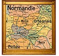
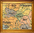
Provinces of France (pre-revolution)
[edit]For some projects, such as genealogical databases like WikiTree, maps become a key resource for properly identifying place names that have changed over time. The French Revolution is a notorious case: a concerted effort was made to purposely dismantle and "reconfigure" all of the historic provinces into new départements - as a way of breaking with the past (i.e. the ancien regime). Maps such as these relate the original provinces of France to their new "départements":
-
.jpg/120px-Alsace_(province).jpg) Alsace
Alsace -
 Angoumois
 -
 Anjou
Anjou -
 Aunis
Aunis -
 Auvergne
 -
 Béarn
Béarn -
 Berry
Berry -
.jpg/250px-Bourbonnais_(province).jpg) Bourbonnais
Bourbonnais -
 Bourgogne
 -
 Bretagne
 -
 Champagne
 -
 Comtat Venaissin
 -
 Comté de Foix
 -
 Dauphiné
 -
 Flandre française
 -
 Franche-Comté
 -
 Gascogne
 -
 Guyenne
 -
 Île-de-France
 -
 Languedoc
 -
 Limousin
 -
 Lorraine
 -
 Lyonnais
 -
 Maine
Maine -
 Marche
 -
.jpg/250px-Nivernais_(province).jpg) Nivernais
Nivernais -
 Normandie
 -
 Orléanais
 -
 Perche
 -
 Picardie
 -
 Poitou
 -
 Provence
 -
.jpg/120px-Roussillon_(province).jpg) Roussillon
Roussillon -
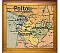 Saintonge
 -
 Touraine
.jpg)


.jpg)


.jpg)


.jpg)


History and Genealogy
[edit]As a contributor on Wikipedia, as well as WikiTree and other genealogical sites, I regularly produce images that relate to historic scenes, individuals and/or places of interest - a few examples of which are below:
-
 Albert II de Namur
 -
 Albert III de Namur
 -
.jpg/250px-Montmorency_(Chartres).jpg) Blazon de Montmorency
Blazon de Montmorency -
.png/250px-Les_Croisés_devant_Béziers_(1209).png) Les Croisés devant Béziers (1209)
Les Croisés devant Béziers (1209) -
.jpg/250px-Tours_-_vue_panoramique_1787_(par_Pierre-Antoine_Demachy_1723-1807).jpg) Vue panoramique de Tours par Pierre-Antoine Demarchy 1787
Vue panoramique de Tours par Pierre-Antoine Demarchy 1787 -
 Armoiries de Sicard de Carufel
 -
 Marie-Olive Sicard de Carufel
 -
 Joseph Casavant (1807-1874)
 -
 Samuel Casavant (1859-1929)


.jpg)
.png)
.jpg)


Note to fellow Wikimedians
[edit]The use of an approximate year (always noted as c. for "circa" because many historic situations were only approximate) helps to organise maps in chronological order - and makes it easier for those searching for a place and time of interest to find it. As should be clear, circa means about - and generally speaking the further back in time one goes, the more a date is an approximation.
The chronological naming standard also facilitates review within categories. For an average user or visitor, they may often have a general need or interest - such as seeing how Germany, Italy or another territory changed during the 1800s. Maps of these countries organised in chronological progression facilitates finding the ideal map or series of maps.
Regarding categorisation, relatively few users are specifically looking for an historic map by precise year, such as the Italian Peninsula in 1723 - or even less likely, a map of the Italian Peninsula as it was in the 18th century that was published in the 1920s. Recategorising broad-based maps into such narrow categories makes it harder for average users to find them. No one is likely to open multiple "drawers" in which maps have been essentially "put away." It's a bit like eliminating a department store that shoppers can browse by section - and instead simply providing a warehouse of closed drawers - great for warehouse personel but not ideal for shoppers or "the business." That being said, there are certainly times when categories become so over-populated that they become difficult to browse. Very often though, it is the subject matter that is the issue, for example, a map of Brussels being placed into a category that is Maps of Belgium.
Applying appropriate standards of categorisation, we generally do not place images into a category unless they depict all or a substantial part of the noted category. So maps of Brussels don't generally belong in the category maps of Belgium. However, a map of northern Europe at a historic time might well include Belgium, the Netherlands, Luxembourg and their neighbors. If a user is interested in seeing the territory of Belgium at a particular period, it's likely it may be represented in a map of the region. If a corresponding regional map removes Belgium as one of the categories noted, then again it's more difficult to be found by a user.
I appreciate that some situations may call for different approaches - particularly if an individual category becomes overly crowded. However, as a Wikimedian professional courtesy, please contact me before changing any file names or redirecting maps into different categories. Some presumably well-intentioned efforts in the past have been erroneous and led to the maps being more difficult for average users to find. I'll do my best to be responsive to any request.
Finally, if you have any particular map-makers or other resources that you think would make helpful additions, please let me know!