
Category:West Lothian Archaeological Trust
| Upload media | |||||
| |||||
Media in category "West Lothian Archaeological Trust"
The following 61 files are in this category, out of 61 total.
-
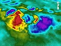 A daytime oblique kite aerial thermogram of Selsley long barrow.jpg 640 × 480; 339 KB
-

-
 A night- time oblique kite aerial thermogram of Selsley long barrow.jpg 640 × 480; 147 KB
-
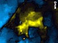
 A thermogram of Cirencester Roman amphitheatre in darkness.jpg 700 × 446; 280 KB
-
 A vertical kite aerial photo of Selsley long barrow.jpg 700 × 482; 544 KB
-

-
 An oblique kite aerial photo of Selsley long Barrow.jpg 604 × 401; 356 KB
-
 Archeoscan excavation site.jpg 1,000 × 1,006; 461 KB
-
 Armadale from the north-west.jpg 2,592 × 1,944; 1.76 MB
-
 Blackness Castle, Blackness, Scotland.jpg 3,648 × 2,736; 4.9 MB
-
 Cairn and Henge on Cairnpapple Hill in West Lothian, Scotland.jpg 600 × 800; 177 KB
-
 Castle Greg Roman Fortlet in West Lothian. Scotland.jpg 800 × 600; 290 KB
-
 Castlethorn Hillfort in West Lothian, Scotland.jpg 600 × 800; 104 KB
-

-
 Etna near ultra-violet kite aerial photo.jpg 600 × 448; 48 KB
-
 Gormyre Hill in West Lothian, Scotland.jpg 500 × 667; 138 KB
-
 Gormyre Hill.jpg 550 × 413; 181 KB
-
 Helicopter outing over the village of Bussage.jpg 463 × 600; 78 KB
-
 Kite aeria photo of Caerwent.jpg 1,000 × 750; 581 KB
-
 Kite aerial photo of a Hoffmann brick kiln.jpg 1,200 × 900; 353 KB
-
 Kite aerial photo of Bolton Abbey.jpg 1,250 × 938; 862 KB
-
 Kite Aerial Photo of Cairnpapple Hill, Cairn and Henge, Scotland.jpg 1,000 × 750; 212 KB
-
 Kite Aerial Photo of Cairnpapple Hill.jpg 927 × 540; 580 KB
-
 Kite aerial photo of crop marks at Nesley, near Tetbury, Gloucestershire.jpg 3,648 × 2,736; 3.05 MB
-
 Kite aerial photo of Linlithgow Palace.jpg 700 × 525; 81 KB
-
 Kite aerial photo of Marling School.JPG 1,000 × 750; 212 KB
-
 Kite aerial photo of Stroud Leisure Centre.JPG 1,000 × 750; 180 KB
-
 Kite aerial photo of the Armadale Academy.JPG 2,848 × 2,136; 3.01 MB
-
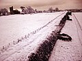
 Kite aerial photo of the Drove Road, Armadale, West Lothian.jpg 1,000 × 750; 242 KB
-
 Kite aerial photo of Thomas Keble School.jpg 3,128 × 2,404; 3.08 MB
-
 Kite aerial photo the site of Ogilface Castle, Woodend, West Lothian in low sunlight.jpg 3,072 × 2,304; 2.88 MB
-
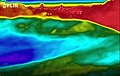
 Kite aerial thermogram of Ogilface Castle.jpg 1,000 × 636; 309 KB
-

-
 Linlithgow Palace at Night.jpg 4,912 × 3,264; 3.53 MB
-

-
%2C_Co_Roscommon%2C_Ireland.jpg/120px-Multivallate_Ringfort_at_Rathrar_(Rathbarna_Enclosure_Complex)%2C_Co_Roscommon%2C_Ireland.jpg)
-
 Museum in the Park, Stroud.jpg 960 × 691; 155 KB
-

-
 Near infra-red kite aerial photo of Kinneil Roman Fortlet.jpg 700 × 525; 138 KB
-
 Near infra-red kite aerial photo of the site of Ogilface Castle, West Lothian.jpg 3,072 × 2,304; 1,014 KB
-
 Night-time vertical aerial thermogram of a former kiln site.jpg 800 × 598; 489 KB
-
 Ogilface Castle.jpg 700 × 525; 239 KB
-

-
 Peace Knowe Hillfort.jpg 800 × 600; 193 KB
-
 Pole aerial photo from above The Royal Castle of Kindrochit in Mar.jpg 3,648 × 2,736; 3.89 MB
-
 Pole aerial photo of The Royal Castle of Kindrochit in Mar.jpg 900 × 675; 472 KB
-
 Roman Road - The Via Julia, Bristol.jpg 511 × 323; 54 KB
-
 Round Dykes Camp on Addingham Low Moor.jpg 900 × 675; 123 KB
-
 Scalpsie Cairn on the Isle of Bute in Scotland.jpg 1,500 × 1,125; 2 MB
-
 SGS Stroud Campus Aerial Photo.jpg 825 × 648; 299 KB
-
 St. Ninian's Chapel on the Isle of Bute, Scotland.jpg 3,072 × 2,304; 4.88 MB
-
 Temporary Roman camps at Lochlands near Camelon in Falkirk.jpg 1,000 × 666; 159 KB
-
 The Hall of Dowager Lady Torphichen in North Lanarkshire south of Blackridge in Scotland.jpg 1,500 × 1,125; 2.63 MB
-

-
 The northern side of Linlithgow Palace in West Lothian, Scotland.jpg 1,000 × 750; 177 KB
-
 The Preceptory, Torphichen, West Lothian..jpg 5,700 × 4,275; 10.81 MB
-
 The site of 'Ogilface' situated one mile to the west of Ogilface Castle in West Lothian.jpg 1,350 × 1,800; 1.77 MB
-
 The site of Ogilface Castle at Woodend in Armadale, West Lothian, Scotland.jpg 2,848 × 2,136; 3.95 MB
-

-
 Thermogram of Cairnpapple Hill.jpg 550 × 343; 17 KB
-
 West Main Street, Armadale, West Lothian.jpg 2,130 × 1,647; 1.07 MB


,_Co_Roscommon,_Ireland.jpg)


