English: Magyarország (Hungary) Maps showing all or most of the territory (geographic area) of modern-day Hungary - as the lands were in the 17th century (1601-1700 CE)
See Wikimedia Commons Atlas of Hungary for a general overview of the territory including its evolution in European history.
Additional maps related to the history of Hungary (including larger entities comprising or controlling the territory, and smaller entities within the territory) can be found at Maps of the history of Hungary.


 Hungary - as the lands were in the 17th century (1601-1700 CE)
 Growth of Habsburg territories.jpg 2,275 × 1,350; 1.02 MB
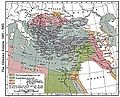 Ottoman empire 1481-1683.jpg 1,636 × 1,321; 458 KB
 Hungary in 1606 XVII century.jpg 1,842 × 1,071; 315 KB
 Magyarország 1606-ban a bécsi és zsitvatoroki béke korában Bánlaky.jpg 2,748 × 1,670; 2.66 MB
 Central Europe religions 1618.jpg 1,358 × 1,414; 463 KB
.jpg/120px-Magyar-_és_Erdélyország_1629-ben_(Pallas).jpg) Magyar- és Erdélyország 1629-ben (Pallas).jpg 2,280 × 1,800; 946 KB
Magyar- és Erdélyország 1629-ben (Pallas).jpg 2,280 × 1,800; 946 KB Koruna ceska 1648.png 481 × 475; 24 KB
 A' budai pasaság 1650-ben Hadzsi Chalfa szerint.png 1,246 × 1,520; 1.62 MB
 C. 1650 Ottoman Empire.jpg 1,520 × 1,081; 1.7 MB
.jpg/120px-C._1699_Hungary_(1526-1699).jpg) C. 1699 Hungary (1526-1699).jpg 3,768 × 2,813; 5.94 MB
C. 1699 Hungary (1526-1699).jpg 3,768 × 2,813; 5.94 MB.jpg/120px-C._1739_Hungary_(1382-1739).jpg) C. 1739 Hungary (1382-1739).jpg 3,879 × 3,031; 4.26 MB
C. 1739 Hungary (1382-1739).jpg 3,879 × 3,031; 4.26 MB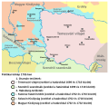 Eyalet of temesvar1699 hu.svg 1,347 × 1,312; 90 KB
 Rákóczi estates.jpg 1,104 × 786; 211 KB


.jpg)


.jpg)
.jpg)

