
Category:Maps of France in the 18th century
English: 
France  France - as the lands were in the 18th century (1701-1800 CE)

Français : Cartes montrant la totalité ou la majeure partie du territoire (la zone géographique) de la France actuelle - comme les terres étaient au XVIIIe siècle (1701-1800 EC)
See Wikimedia Commons Atlas of France for a general overview of the territory including its evolution in European history.
Additional maps related to the history of France (including larger entities comprising or controlling the territory, French-controlled entities outside of the territory, and smaller entities within the territory) can be found at Maps of the history of France.
Maps of the history of France: (BCE) 1st century · (CE) 1st century · 2nd century · 3rd century · 4th century · 5th century · 6th century · 7th century · 8th century · 9th century · 10th century · 11th century · 12th century · 13th century · 14th century · 15th century · 16th century · 17th century · 18th century · 19th century · 20th century · 21st century ·
Subcategories
This category has the following 4 subcategories, out of 4 total.
Media in category "Maps of France in the 18th century"
The following 34 files are in this category, out of 34 total.
-
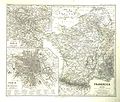
 Atlas général de la France - France 1715 - E. Cortambert.jpg 1,700 × 1,709; 428 KB
-
.jpg/120px-22_of_%27The_History_of_the_French_Revolution%2C_1789_to_1795%3B_or_a_country_without_a_God%27_(11204954196).jpg)
-
.jpg/120px-394_of_%27La_France_Illustrée-_géographie_générale_..._Par_F._J%27_(11291686503).jpg) 394 of 'La France Illustrée- géographie générale ... Par F. J' (11291686503).jpg 1,183 × 1,170; 415 KB
394 of 'La France Illustrée- géographie générale ... Par F. J' (11291686503).jpg 1,183 × 1,170; 415 KB
-
 France Ancien Régime Diocèses 1789.png 1,950 × 1,914; 2.63 MB
-
 France anciennes provinces 1789.jpg 1,147 × 916; 343 KB
-
 France ecc 1789 1802.jpg 1,114 × 943; 291 KB
-
 Provinces of France 1322-1789.png 2,388 × 2,452; 10.31 MB
-
 C. 1789 and 1802 France Ecclesiastical.jpg 1,517 × 1,297; 1.26 MB
-
.jpg/120px-C._1789_France_(Gouvernements).jpg) C. 1789 France (Gouvernements).jpg 1,496 × 1,186; 1.59 MB
C. 1789 France (Gouvernements).jpg 1,496 × 1,186; 1.59 MB
-
 Vidal-Lablache n°9 - Provinces en 1789.jpg 6,918 × 5,806; 48.15 MB
-
 Atlas général de la France - France 1791 - E. Cortambert.jpg 1,738 × 1,697; 417 KB
-
 Polens andra delning.jpg 766 × 719; 321 KB
-
 France1911dev.png 2,046 × 2,780; 3.94 MB
-
 Traites en France.svg 870 × 713; 1.12 MB
-
.jpg/120px-thumbnail.jpg)
-
.jpg/120px-C._1601-1766_France_(extensions_of_northeastern_frontier).jpg) C. 1601-1766 France (extensions of northeastern frontier).jpg 1,885 × 1,293; 1.29 MB
C. 1601-1766 France (extensions of northeastern frontier).jpg 1,885 × 1,293; 1.29 MB
-
.jpg/120px-C._1601-1766_France_(extensions_of_southern_frontier).jpg) C. 1601-1766 France (extensions of southern frontier).jpg 1,674 × 1,405; 2.24 MB
C. 1601-1766 France (extensions of southern frontier).jpg 1,674 × 1,405; 2.24 MB
-
 C. 1601-1766 France frontiers.jpg 1,252 × 1,790; 2.53 MB
-
.jpg/120px-C._1790_France_(1600-1790).jpg) C. 1790 France (1600-1790).jpg 3,000 × 4,000; 5.6 MB
C. 1790 France (1600-1790).jpg 3,000 × 4,000; 5.6 MB
-
 D044- N° 431. Les Guerres de la Révolution. - Liv3-Ch16.png 1,445 × 1,877; 287 KB
-
 France departments 1791.jpg 1,108 × 896; 301 KB
-
 France generalities 1789.jpg 1,154 × 911; 269 KB
-
 France gouvernements 1789.jpg 1,147 × 916; 274 KB
-
 France laws and courts 1789.jpg 1,141 × 915; 291 KB
-
 France salt tax 1789.jpg 1,136 × 915; 299 KB
-
 France-LouisXIV-Traité de Ryswick.jpg 492 × 663; 97 KB
-
 Généralité-de-Montauban 1716-1790.jpg 1,920 × 1,336; 265 KB
-
.svg/120px-Kingdom_of_France_(1792).svg.png) Kingdom of France (1792).svg 450 × 456; 928 KB
Kingdom of France (1792).svg 450 × 456; 928 KB
-
.jpg/120px-Leers(XVIIIème).jpg) Leers(XVIIIème).jpg 3,214 × 2,551; 659 KB
Leers(XVIIIème).jpg 3,214 × 2,551; 659 KB
-
 Map of the Habsburg Netherlands by Alexis-Marie Gochet.png 532 × 744; 813 KB
-
_numéros.svg/120px-Parlements_Royaume_de_France_(1789)_numéros.svg.png) Parlements Royaume de France (1789) numéros.svg 2,000 × 1,922; 906 KB
Parlements Royaume de France (1789) numéros.svg 2,000 × 1,922; 906 KB
-
 Spruner-Menke Handatlas 1880 Karte 55.jpg 3,499 × 2,988; 1.57 MB
-
.jpg/120px-thumbnail.jpg)
-
.jpg/120px-Spruner-Menke_Hand-Atlas_fur_die_Geschichte_des_Mittelalters_und_der_neueren_Zeit._1880_(137087292).jpg)

.jpg)
.jpg)


.jpg)


.jpg)
.jpg)
.jpg)

.jpg)


.svg)
.jpg)

_numéros.svg)

.jpg)
.jpg)