
Category:Kinghorn

town and parish in Fife, Scotland, UK  | |||||
| Upload media | |||||
| Instance of | |||||
|---|---|---|---|---|---|
| Location |
| ||||
| Population |
| ||||
 | |||||
Subcategories
This category has the following 8 subcategories, out of 8 total.
B
- Kinghorn beach (16 F)
K
- Kinghorn Town Hall (2 F)
- Kinghorn war memorial (2 F)
L
- Kinghorn Loch (8 F)
P
R
- Kinghorn railway station (6 F)
S
Media in category "Kinghorn"
The following 200 files are in this category, out of 352 total.
(previous page) (next page)-
 "Iron Design by Rory" - geograph.org.uk - 7129689.jpg 1,024 × 768; 182 KB
-
.jpg/120px-2016_-_January_Fife_Walk_(24254461266).jpg) 2016 - January Fife Walk (24254461266).jpg 4,928 × 3,264; 1.62 MB
2016 - January Fife Walk (24254461266).jpg 4,928 × 3,264; 1.62 MB
-
 A commanding view of Kinghorn Harbour - geograph.org.uk - 7127744.jpg 1,024 × 768; 175 KB
-
 A gull looks down on Kinghorn - geograph.org.uk - 1982212.jpg 480 × 640; 110 KB
-
 A pier at Pettycur - geograph.org.uk - 2487254.jpg 640 × 394; 51 KB
-
 A921 Burntisland Road near the Bay Hotel - geograph.org.uk - 6420881.jpg 800 × 606; 117 KB
-
 A921 Kinghorn Road towards Kinghorn - geograph.org.uk - 6442244.jpg 800 × 550; 122 KB
-
 A921 Kinghorn Road towards Kirkcaldy - geograph.org.uk - 6441202.jpg 800 × 543; 130 KB
-
 Abden Avenue - geograph.org.uk - 7341739.jpg 1,600 × 1,067; 277 KB
-
 Access Gate - geograph.org.uk - 5419284.jpg 640 × 425; 138 KB
-
 Across the A921 to the sands - geograph.org.uk - 3537344.jpg 640 × 427; 249 KB
-
 Alexander III Monument - geograph.org.uk - 7994790.jpg 5,184 × 3,888; 6.05 MB
-
 Alexander III monument along the A921 - geograph.org.uk - 6420878.jpg 800 × 543; 129 KB
-
 Alexander III Monument at Kinghorn - geograph.org.uk - 2370736.jpg 480 × 640; 99 KB
-
 Alexander III monument beside the A921 - geograph.org.uk - 6126769.jpg 1,600 × 1,138; 379 KB
-
 Alexander III Monument panel - geograph.org.uk - 2370731.jpg 640 × 486; 72 KB
-
 Alexander III Monument panels - geograph.org.uk - 2370714.jpg 480 × 640; 70 KB
-
 Alexander III Monument poem - geograph.org.uk - 2370739.jpg 640 × 482; 90 KB
-
 Alexander III Monument, Kinghorn - geograph.org.uk - 2370708.jpg 480 × 640; 59 KB
-
 Approaching Seafield Tower - geograph.org.uk - 6298217.jpg 640 × 480; 73 KB
-
 Artificial island in Kinghorn Loch - geograph.org.uk - 7137787.jpg 1,024 × 768; 178 KB
-
 Banchory - geograph.org.uk - 75071.jpg 640 × 480; 281 KB
-
 Barn at Craigencalt Mill - geograph.org.uk - 7137783.jpg 1,024 × 768; 252 KB
-

-
 Beach and harbour at Kinghorn - geograph.org.uk - 6225720.jpg 800 × 513; 106 KB
-
 Beach and harbour at Kinghorn - geograph.org.uk - 6422420.jpg 800 × 566; 132 KB
-
 Beach and sea defences at Kinghorn - geograph.org.uk - 6422430.jpg 800 × 561; 138 KB
-
 Beach at Pettycur Bay - geograph.org.uk - 2487286.jpg 640 × 494; 64 KB
-
 Beach at western side of Kinghorn - geograph.org.uk - 7031876.jpg 5,184 × 2,912; 3.97 MB
-
 Beach between Kinghorn and Burntisland - geograph.org.uk - 3821308.jpg 640 × 408; 231 KB
-
 Beach Cleaning Station - geograph.org.uk - 6298207.jpg 640 × 480; 100 KB
-
 Beach north of Kinghorn - geograph.org.uk - 2565953.jpg 640 × 413; 405 KB
-
 Beach west of Pettycur - geograph.org.uk - 3821317.jpg 640 × 480; 393 KB
-
 Binnend Borehole - geograph.org.uk - 6502183.jpg 800 × 533; 209 KB
-
 Bird hide on Kinghorn Loch - geograph.org.uk - 7137777.jpg 1,024 × 768; 298 KB
-
 Black Rocks - geograph.org.uk - 7128606.jpg 1,024 × 768; 153 KB
-
 Boats at Pettycur - geograph.org.uk - 1982195.jpg 640 × 484; 109 KB
-
 Boats in the harbour at Kinghorn - geograph.org.uk - 6422416.jpg 800 × 585; 151 KB
-
 Boundary fence of Kinghorn Harbour Holiday Park - geograph.org.uk - 7129697.jpg 1,024 × 768; 184 KB
-
 Bridge across the railway line - geograph.org.uk - 6420897.jpg 800 × 537; 101 KB
-
 Burntisland from Pettycur Bay - geograph.org.uk - 3389954.jpg 3,264 × 2,448; 3.46 MB
-
 Burntisland Golf House Club, 5th Hole, The Pond - geograph.org.uk - 7246626.jpg 5,184 × 3,888; 6.05 MB
-
 Burntisland Sands - geograph.org.uk - 7128609.jpg 1,024 × 735; 100 KB
-
 Burntisland Sands - geograph.org.uk - 7128907.jpg 1,024 × 768; 222 KB
-
 Car Park on Kinghorn Loch - geograph.org.uk - 7137856.jpg 1,024 × 768; 166 KB
-
 Caravan holiday parks - geograph.org.uk - 6574166.jpg 5,694 × 3,251; 2.76 MB
-
 Carlin Craig at Pettycur - geograph.org.uk - 6422088.jpg 800 × 527; 102 KB
-
 Carlinhead Rocks - geograph.org.uk - 7129682.jpg 1,024 × 768; 95 KB
-
 Cascade at Craigencalt Mill - geograph.org.uk - 7137781.jpg 1,024 × 768; 335 KB
-
 Church Hall and War Memorial - geograph.org.uk - 962479.jpg 640 × 480; 60 KB
-
 Clifftop near Kinghorn - geograph.org.uk - 7603377.jpg 1,024 × 684; 190 KB
-
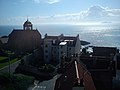
 Coastal Fife , Kinghorn Parish Church - geograph.org.uk - 3519131.jpg 1,600 × 1,200; 273 KB
-
 Coastal rocks and beach - geograph.org.uk - 7129967.jpg 1,024 × 768; 171 KB
-
 Cows in field - geograph.org.uk - 6568508.jpg 5,973 × 3,715; 3.55 MB
-
 Craigencalt Farm Shop - geograph.org.uk - 6935831.jpg 4,031 × 2,621; 2.8 MB
-
 Craigencalt Mill - geograph.org.uk - 6562128.jpg 5,216 × 3,373; 5.04 MB
-
 Craigencalt Mill - geograph.org.uk - 6562132.jpg 2,943 × 2,179; 1.18 MB
-
 Cranesbill on the Fife coast - geograph.org.uk - 1982222.jpg 640 × 480; 101 KB
-
 Crinoid Fossils - geograph.org.uk - 2565977.jpg 640 × 427; 482 KB
-
 Cross-bedding - geograph.org.uk - 2566128.jpg 640 × 426; 399 KB
-
 Cygnets on the shore of Kinghorn Loch - geograph.org.uk - 7137810.jpg 1,024 × 768; 249 KB
-
 Dam at eastern end of Kinghorn Loch - geograph.org.uk - 7137887.jpg 1,024 × 768; 223 KB
-
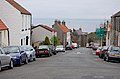
 David the First Street, Kinghorn - geograph.org.uk - 1154166.jpg 640 × 480; 66 KB
-
 Dipping Strata - geograph.org.uk - 2565945.jpg 640 × 413; 377 KB
-
 Dire fates, Whinnyhill landfill site - geograph.org.uk - 7439844.jpg 1,024 × 768; 268 KB
-
 Driftwood above Pettycur Bay. - geograph.org.uk - 7129061.jpg 1,024 × 768; 254 KB
-
 Driftwood above the beach at Pettycur Bay - geograph.org.uk - 7128910.jpg 1,024 × 768; 270 KB
-
 Earthship Fife - geograph.org.uk - 6562115.jpg 5,293 × 3,535; 3.83 MB
-
 Earthship Fife car park - geograph.org.uk - 6562056.jpg 5,695 × 3,500; 3.53 MB
-
 East Bay Forth Rail Bridge.jpg 882 × 661; 186 KB
-
 Ecological allotments - geograph.org.uk - 5182587.jpg 2,560 × 1,920; 3.27 MB
-
 Ecology Centre, Kinghorn Loch - geograph.org.uk - 7137869.jpg 1,024 × 768; 247 KB
-
 Ecology Centre, Kinghorn Loch - geograph.org.uk - 7137870.jpg 1,024 × 768; 151 KB
-
 Edinburgh - Dundee railway - geograph.org.uk - 1480633.jpg 640 × 457; 71 KB
-
 Electric vehicle charging point - geograph.org.uk - 6562118.jpg 3,292 × 4,170; 3.08 MB
-
 Farmland near the Grange - geograph.org.uk - 6441185.jpg 800 × 551; 138 KB
-
 Fault Breccia - geograph.org.uk - 2566060.jpg 418 × 640; 451 KB
-
 Fault in the Rocks - geograph.org.uk - 2566102.jpg 425 × 640; 412 KB
-
 Fergus the Troll - geograph.org.uk - 6562016.jpg 5,568 × 3,553; 4.03 MB
-
 Fields north of Kinghorn - geograph.org.uk - 5721652.jpg 3,264 × 2,448; 3.07 MB
-
 Fife coast at Kinghorn - geograph.org.uk - 5908376.jpg 1,024 × 768; 123 KB
-
 Fife coast east of Seafield - geograph.org.uk - 3877341.jpg 640 × 427; 371 KB
-
 Fife Coastal Path - geograph.org.uk - 3408378.jpg 1,600 × 1,132; 147 KB
-
 Fife Coastal Path - geograph.org.uk - 7129698.jpg 1,024 × 768; 174 KB
-
 Fife Coastal Path - geograph.org.uk - 7129699.jpg 1,024 × 768; 138 KB
-
 Fife Coastal Path and Seafield Tower - geograph.org.uk - 6423696.jpg 800 × 471; 81 KB
-
 Fife Coastal Path at Bellypuff, Kinghorn - geograph.org.uk - 6422577.jpg 800 × 481; 120 KB
-
 Fife Coastal Path at Hoch-ma-Toch - geograph.org.uk - 6422587.jpg 800 × 515; 150 KB
-
 Fife Coastal Path at Kinghorn - geograph.org.uk - 6422339.jpg 800 × 535; 120 KB
-
 Fife Coastal Path at Kinghorn - geograph.org.uk - 6422453.jpg 800 × 434; 123 KB
-
 Fife Coastal Path towards Kirkcaldy - geograph.org.uk - 6422624.jpg 800 × 548; 95 KB
-
 Fife Coastal Path towards Kirkcaldy - geograph.org.uk - 6423581.jpg 800 × 567; 164 KB
-
 Fife Coastal Path towards Kirkcaldy - geograph.org.uk - 6423687.jpg 800 × 511; 119 KB
-
 Fife Coastal Path, Kinghorn - geograph.org.uk - 1154192.jpg 640 × 480; 74 KB
-
 Fife coastal path, Kinghorn - geograph.org.uk - 1479719.jpg 640 × 480; 119 KB
-
 Fife Coastline - geograph.org.uk - 879867.jpg 640 × 425; 58 KB
-
 Fife farmland near Linton Court - geograph.org.uk - 6442249.jpg 800 × 600; 157 KB
-

-
 Firth of Forth - geograph.org.uk - 7603301.jpg 1,024 × 684; 165 KB
-
 Firth of Forth - geograph.org.uk - 7603306.jpg 1,024 × 684; 142 KB
-
 Flats, South Overgate - geograph.org.uk - 1474643.jpg 640 × 480; 93 KB
-
 Flood damage - geograph.org.uk - 6574142.jpg 5,627 × 3,618; 3.45 MB
-
 Flood damage - geograph.org.uk - 6574147.jpg 5,351 × 3,496; 4.84 MB
-
 Flooded cutting - geograph.org.uk - 1594868.jpg 640 × 359; 134 KB
-
 Foreshore near Kinghorn - geograph.org.uk - 2565842.jpg 640 × 425; 412 KB
-
 Foreshore near Linton Court - geograph.org.uk - 2566037.jpg 640 × 424; 449 KB
-
 Foreshore near Linton Court - geograph.org.uk - 2566076.jpg 640 × 420; 405 KB
-
 Former Kinghorn Primary School, Kinghorn.jpg 3,264 × 2,448; 2.9 MB
-
 From an Edinburgh-Dundee train - Kinghorn - geograph.org.uk - 7814761.jpg 1,600 × 1,200; 353 KB
-

-

-
 Gable, Woodfield - geograph.org.uk - 7439496.jpg 1,024 × 768; 168 KB
-
 Gateway to Grangehill - geograph.org.uk - 5419225.jpg 640 × 425; 108 KB
-
 Grangehill Farm - geograph.org.uk - 5419164.jpg 640 × 425; 103 KB
-
 Grassland - geograph.org.uk - 7603378.jpg 1,024 × 684; 186 KB
-
 Gravestone, Kinghorn Parish Church - geograph.org.uk - 3821597.jpg 480 × 640; 522 KB
-
 Gravestones at Kinghorn Cemetery - geograph.org.uk - 6442262.jpg 800 × 518; 129 KB
-
 Graveyard at Kinghorn Parish Church - geograph.org.uk - 6422447.jpg 800 × 513; 108 KB
-
 Harbour at Pettycur - geograph.org.uk - 3821416.jpg 640 × 413; 442 KB
-
 Harbour Bay and Beach, Kinghorn - geograph.org.uk - 7129685.jpg 1,024 × 768; 168 KB
-
 Harbour Kinghorn - geograph.org.uk - 6374605.jpg 1,024 × 683; 99 KB
-
 High road to Craigencalt - geograph.org.uk - 7342341.jpg 1,600 × 1,067; 293 KB
-
 High Street , Kinghorn - geograph.org.uk - 1479715.jpg 640 × 480; 78 KB
-
 Houses by main line - geograph.org.uk - 8036078.jpg 1,024 × 684; 207 KB
-
 I Saw Three Ships - geograph.org.uk - 2565905.jpg 640 × 415; 368 KB
-
 Inch View at Pettycur - geograph.org.uk - 6420928.jpg 800 × 583; 113 KB
-
 Inchkeith - geograph.org.uk - 7439836.jpg 1,024 × 768; 90 KB
-
 Information Board in car park - geograph.org.uk - 6562138.jpg 3,006 × 4,828; 2.86 MB
-
 Information Board in car park - geograph.org.uk - 6562143.jpg 3,750 × 3,756; 2.78 MB
-
 Kiln Rocks - geograph.org.uk - 2565925.jpg 640 × 421; 410 KB
-
 Kiln Rocks - geograph.org.uk - 2565968.jpg 640 × 416; 424 KB
-
 Kiln Rocks along the Fife coastline - geograph.org.uk - 6422613.jpg 800 × 507; 135 KB
-
 King Alexander III Monument near Kinghorn - geograph.org.uk - 7031875.jpg 5,184 × 2,912; 3.45 MB
-
.jpg/120px-Kinghorn_(49595380357).jpg) Kinghorn (49595380357).jpg 4,958 × 2,271; 9.63 MB
Kinghorn (49595380357).jpg 4,958 × 2,271; 9.63 MB
-
_-_Flickr_-_jkiscycling.jpg/120px-Kinghorn_(Explored_09-01-22)_-_Flickr_-_jkiscycling.jpg) Kinghorn (Explored 09-01-22) - Flickr - jkiscycling.jpg 7,952 × 5,304; 3.82 MB
Kinghorn (Explored 09-01-22) - Flickr - jkiscycling.jpg 7,952 × 5,304; 3.82 MB
-
Kinghorn (older, local).ogg 1.6 s; 30 KB
-
 Kinghorn - geograph.org.uk - 2566152.jpg 640 × 415; 408 KB
-
 Kinghorn - geograph.org.uk - 316681.jpg 640 × 424; 31 KB
-
 Kinghorn - geograph.org.uk - 423295.jpg 640 × 424; 54 KB
-
 Kinghorn - geograph.org.uk - 423311.jpg 640 × 516; 134 KB
-
 Kinghorn - geograph.org.uk - 423808.jpg 640 × 424; 52 KB
-
 Kinghorn - geograph.org.uk - 423836.jpg 640 × 424; 68 KB
-
 Kinghorn - geograph.org.uk - 423873.jpg 640 × 424; 52 KB
-
 Kinghorn - geograph.org.uk - 5427222.jpg 640 × 427; 368 KB
-
 Kinghorn - Path leading down to St James Place - geograph.org.uk - 7031883.jpg 5,184 × 2,912; 4.62 MB
-
 Kinghorn - St James Place - geograph.org.uk - 7031885.jpg 5,184 × 2,912; 4.28 MB
-
 Kinghorn - St James Place - geograph.org.uk - 7031886.jpg 5,184 × 2,912; 4.28 MB
-
 Kinghorn along the Fife coastline - geograph.org.uk - 6422351.jpg 800 × 560; 162 KB
-
 Kinghorn and Pettycur from the air - geograph.org.uk - 2208901.jpg 2,592 × 1,451; 1.15 MB
-
 Kinghorn and the Fife Coast - geograph.org.uk - 3009940.jpg 3,264 × 2,448; 2.66 MB
-
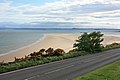
 Kinghorn Bay - geograph.org.uk - 23959.jpg 640 × 480; 77 KB
-
 Kinghorn Bay - geograph.org.uk - 2571047.jpg 640 × 480; 84 KB
-
 Kinghorn Bay - geograph.org.uk - 310780.jpg 640 × 480; 67 KB
-
 Kinghorn Beach - geograph.org.uk - 5769107.jpg 5,706 × 3,475; 4.5 MB
-
 Kinghorn Beach - geograph.org.uk - 6298206.jpg 640 × 480; 78 KB
-
 Kinghorn Beach and harbour - geograph.org.uk - 6422344.jpg 800 × 561; 79 KB
-
 Kinghorn beach at St James Place - geograph.org.uk - 6298209.jpg 640 × 480; 100 KB
-
 Kinghorn cottages - geograph.org.uk - 5182602.jpg 2,560 × 1,920; 871 KB
-
 Kinghorn from the air - geograph.org.uk - 4072041.jpg 480 × 640; 99 KB
-
 Kinghorn from the air - geograph.org.uk - 6644450.jpg 1,024 × 556; 497 KB
-
 Kinghorn from the coastal path to the NE - geograph.org.uk - 2525859.jpg 2,592 × 1,944; 1.68 MB
-
 Kinghorn graveyard and Parish Church - geograph.org.uk - 7006996.jpg 640 × 480; 64 KB
-
 Kinghorn Harbour - geograph.org.uk - 2525885.jpg 2,592 × 1,944; 1.59 MB
-
 Kinghorn Harbour - geograph.org.uk - 3234364.jpg 3,648 × 2,736; 1.06 MB
-
 Kinghorn Harbour - geograph.org.uk - 3520788.jpg 3,264 × 2,448; 4.09 MB
-
 Kinghorn Harbour - geograph.org.uk - 3677252.jpg 1,024 × 768; 164 KB
-
 Kinghorn Harbour - geograph.org.uk - 6298203.jpg 640 × 480; 87 KB
-
 Kinghorn Harbour - geograph.org.uk - 7031881.jpg 5,184 × 2,912; 1.58 MB
-
 Kinghorn Harbour Holiday Park - geograph.org.uk - 4992178.jpg 640 × 317; 100 KB
-
 Kinghorn Harbour Holiday Park - geograph.org.uk - 4992181.jpg 640 × 324; 98 KB
-
 Kinghorn Harbour.jpg 2,288 × 1,712; 1.32 MB
-
 Kinghorn Loch - geograph.org.uk - 6562024.jpg 5,983 × 3,603; 5.07 MB
-
 Kinghorn Loch - geograph.org.uk - 6562028.jpg 5,799 × 3,691; 4.52 MB
-
 Kinghorn Loch - geograph.org.uk - 6562033.jpg 5,995 × 3,787; 3.89 MB
-
 Kinghorn Loch - geograph.org.uk - 6562043.jpg 5,675 × 3,610; 4.59 MB
-
 Kinghorn Loch - geograph.org.uk - 6562045.jpg 5,635 × 3,820; 5.11 MB
-
 Kinghorn Loch - geograph.org.uk - 6562047.jpg 5,765 × 3,641; 4 MB
-
 Kinghorn Loch - geograph.org.uk - 6562049.jpg 5,699 × 3,769; 3.95 MB
-
 Kinghorn Loch - geograph.org.uk - 6562052.jpg 5,818 × 3,698; 2.63 MB
-
 Kinghorn Loch - geograph.org.uk - 6562054.jpg 2,850 × 2,516; 1.35 MB
-
 Kinghorn Loch - geograph.org.uk - 6935828.jpg 4,032 × 2,760; 2.65 MB
-
 Kinghorn Ness from the air - geograph.org.uk - 2725508.jpg 640 × 381; 111 KB
-
 Kinghorn parish church - geograph.org.uk - 2508721.jpg 730 × 1,024; 104 KB
-
 Kinghorn Parish Church - geograph.org.uk - 316493.jpg 640 × 424; 43 KB
-
 Kinghorn Parish Church - geograph.org.uk - 3408338.jpg 1,600 × 1,062; 160 KB
-
 Kinghorn Parish Church - geograph.org.uk - 4992195.jpg 640 × 403; 129 KB
-
 Kinghorn Parish Church - geograph.org.uk - 4992199.jpg 640 × 384; 117 KB
-
 Kinghorn Parish Church - geograph.org.uk - 7341736.jpg 1,600 × 1,067; 280 KB
-
 Kinghorn Parish church - geograph.org.uk - 7603353.jpg 1,024 × 684; 150 KB
-
 Kinghorn Pier - geograph.org.uk - 7129097.jpg 1,024 × 768; 115 KB
-
 Kinghorn railway viaduct looking towards harbour.jpg 3,088 × 2,056; 1.34 MB
-
 Kinghorn Sailing Club - geograph.org.uk - 5769101.jpg 5,675 × 3,392; 3.71 MB
-
 Kinghorn Shoreline - geograph.org.uk - 2162090.jpg 640 × 333; 57 KB
-
 Kinghorn Station - geograph.org.uk - 7603346.jpg 1,024 × 684; 107 KB
-
 Kinghorn Station - geograph.org.uk - 7603350.jpg 1,024 × 684; 130 KB
-
 Kinghorn Station - geograph.org.uk - 8036079.jpg 1,024 × 558; 165 KB
-
 Kinghorn Station - geograph.org.uk - 8036080.jpg 1,024 × 709; 191 KB
-
 Kinghorn, from over the Firth of Forth - geograph.org.uk - 4547668.jpg 3,264 × 2,448; 3.4 MB
-
Kinghorn.ogg 0.8 s; 19 KB
-
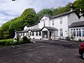 Kingswood Hotel - geograph.org.uk - 3988840.jpg 4,608 × 3,456; 3.32 MB

.jpg)


.jpg)
_-_Flickr_-_jkiscycling.jpg)


